Return to Goat Mountain. How befitting for …. a Goat? …. Boy?
Origin date 7/3/25
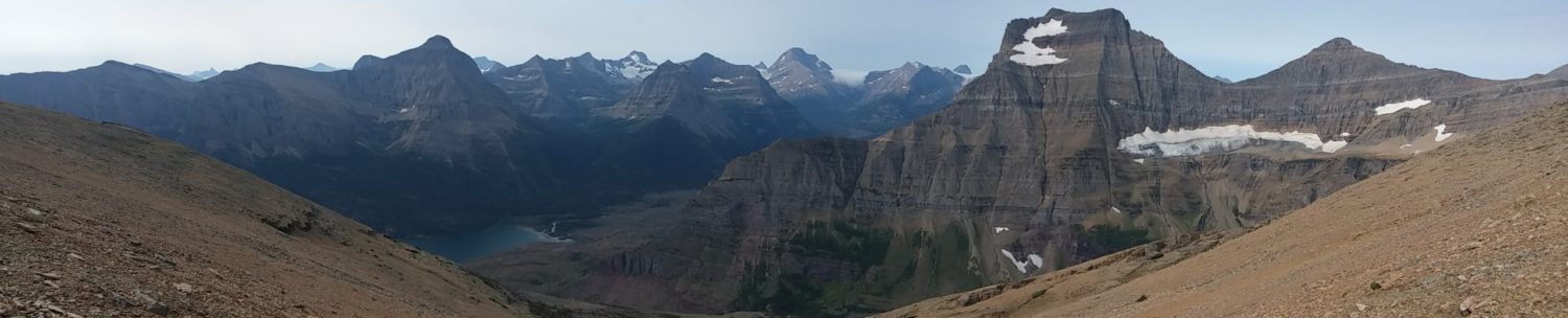
Goat Mountain might be as boring as the name suggests. Or maybe not. The distance is pretty moderate at just over six miles round-trip. But the gain requires pretty solid commitment at just under 4,000 feet. That’s an AVERAGE grade of 26%, with the upper slopes reaching 40%+. Time to put on the big boy pants.

The route comes across as a little unimaginative. This is what I call a classic Glacier Park bowl climb. Given that the Park has been glaciated about twenty times over the last million or so years, these mountains are but shadows of their former selves.

These hills have been chewed at every flank multiple times. The peaks tend to be the confluence of countless hanging valleys, which were nibbled away bit by bit, only to leave razor ridges and triangular summits. And, you guessed it, great big bowls, akin to being carved out with giant ice cream scoops.

Now, with a big bowl hill like this, there is an upside: you are in the shade for a very long time. The sun has to rise in front of me given the peak’s particular orientation. I have until 9 or 10 am before the full brunt of that angry orb’s blinding light (and heat) catches me.

The downside is that these bowls are HUGE and go on forever. If you aren’t checking your altimeter, you’ll feel like you haven’t gained any elevation for over an hour. Then the next hour. Then the next. This climb is extremely similar to the likes of Henkel, Crowfeet, and even Going-to-the-Sun Mountain.

Finding a good drainage gully here or there that has been dry for a few weeks provides some vertical relief (as I call it). I always seek out the natural staircases carved into the million-year-old sedimentary rock for which Glacier is known.

The approach is off the Sun Road at popular Sunrift Gorge, so you really need to be up early to get a parking spot for the few hours the trip will take you. Years ago I always liked hiking through this valley. Not so much recently. The Reynolds fire of 2016 has turned the forest into a ghost town.

If you take the valley all the way back to the headwall, you will be at Siyeh Pass. Off to the left are some of my favorite mountains, including Going to the Sun and Matahpi. There is even an old Great Northern RR trail that takes you to a glacier (Sexton).

Goat Mountain is truly massive. All you can hear is the waterfall coming off that glacial ice 2000 feet up, cascading from those incredible banded layers of ancient stone, formed on an equally ancient seabed floor millions of years ago. What is not to love?

This time, I wanted to keep a little farther off to the right of the main drainage. It leads to the upper scree field and eventually to the great dome summit (which is actually on a very long, winding razor’s edge). The interesting thing is that the climbers’ trail starts as a very human, distinct trail (but not on the map) from a switchback just off the NPS-maintained trail to Siyeh Pass.

I theorize there once was a horse trail to the top of Goat Mtn, and there were many more such trails on these big but gradually sloped summits that did not have many cliff faces to cross. Currently, Glacier has about 750 miles of maintained trail.

Let’s go back to the heyday of the pack saddle tours from about 1915 to 1930. All a high-paying tourist had to do was sit on a horse and take in the 360-degree views. Wranglers make money wowing their guests, and the Great Northern had carte blanche from the NPS to construct almost anything they wanted to.

In that era, there would have been closer to a thousand trail miles of Montana mountain eye-candy for the visiting East Coast elite and the Midwest industrialists. The last pack saddle tour company folded in 1933, and the few tourists who could afford to travel our national parks during the Great Depression embraced the automobile as the preferred (and forward-looking) method of sightseeing.

Many miles of ‘horse to hiking’ trail were lost. No longer maintained, they started returning to the wilderness. More importantly, they fell off the maps as the now hiking-only trail updates were made in the late 1940s through the 1960s.

But just because you don’t know those old trails are there doesn’t mean they’re gone. And I thought this was a good chance to find out. So instead of going directly up the drainage and following some cairns left by the countless climbers before me, I began meandering.

Thinking back to what things were like a hundred years ago. If I were a wrangler or tour guide, what would I want my guests to see up here? The summit of Goat Mountain would be just a little side trip off Siyeh Pass. So it couldn’t take too much time, but you didn’t want them to feel rushed. Personally, I would seek long, lazy switchbacks to the top. Ones that would take me back toward the mouth of the valley for a pristine view of St Mary Lake.

I would like to avoid those cliff bands, so climb a little higher over there. Where does the spring snow accumulate? I’d need to avoid any snowfield that would linger too deep into summer. Which part of the summit ridge do I want to crest first? Frame with perfection the first breathtaking view of that cirque lake 3000 below on the back side.

My climb was quiet and steady. Ultra aware of everything around me. The fauna and flora. The sky and rocks. Every shadow as it gave way to full sun. I took the long crisscrosses over the scree slopes as I slowly wound my way to the summit ridge.

I would occasionally find a 30-foot stretch of abandoned trail that looked as if it had just been built. I would come across oddly arranged boulders that could only be an old switchback. I squeezed through a clump of ancient but stunted subalpine fir krummholz and found a tree that clearly bore a 100-year-old axe-blaze.

I probably found 80% of the old trail below the tree line. You cut a trail in the wilderness at Glacier, and it will literally last hundreds of years, whether used or not. The upper scree on the mountain was much less forgiving. A lot of braided, thin game trails, but nothing from Glacier’s Gilded Age of the horse.

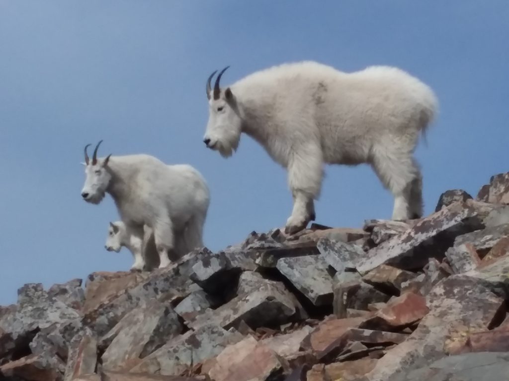
The scree is always crumbling, settling, and shifting like the sands of any great desert. The marks of man are not meant to last here. But I was able to find a lot of history by just looking. Taking my time to be one with the mountain. At peace. Here only to look. Observe. Not take.

This summer, after spending so much time on St Mary Lake (now so far below), I’m starting to see the East Side of the Park in a whole new light. Everybody always fights tooth and nail to get into the Many Glacier Valley. But there is so much more to be had on this pristine 17-mile approach on the Sun Road to Logan Pass.

From this simple vantage, you see all of the classic glaciers that have been written about and hiked across for well over a century now. You can connect them to the very history that helped create this national park.

But I guess you can be the judge. Here is my less-than-a-minute in the sky. Too much wind to talk over.
The hike back to the Delica was pleasant and uneventful. Walking through the skeleton trees is always a little on the spooky side, even in broad daylight. When the wind kicks up just a bit, they howl and scream like the lost souls in perpetual torment. With a little of the vibe from the 1970s version of The Exorcist.

Timing was simple and planned perfection, as the heat was just coming on as I rolled the van door back and got out of those hot boots. Early afternoon return. Time to get back to Beargrass and do some laundry!!!

Not a bad way to spend the day off. Now I just have to start looking for a little company. Hiking alone is boring. Even Moth Man has to have a sidekick. But wait, we haven’t gotten to that story yet.
GoatBoy out!
And Patrick sucks. But by now, we all know that.


 Total views : 1530487